%20--%3e%3cdefs%3e%3cstyle%3e%20.st0%20{%20fill:%20%23989aa5;%20}%20.st1%20{%20fill:%20%230051bb;%20}%20%3c/style%3e%3c/defs%3e%3cg%3e%3cpolygon%20class='st0'%20points='69.2602%2069.4737%20104.6531%2069.4737%20104.6531%2060.4924%2078.1083%2060.4924%2078.1083%2051.6441%20100.2289%2051.6441%20100.2289%2042.796%2078.1083%2042.796%2078.1083%2033.9477%20104.6531%2033.9477%20104.6531%2025.0574%2069.2602%2025.0574%2069.2602%2069.4737'/%3e%3cpolygon%20class='st0'%20points='160.1877%2054.5947%20138.0841%2025.1016%20129.219%2025.0574%20129.219%2069.3406%20138.0841%2069.3406%20138.0841%2039.8726%20160.1877%2069.3406%20169.0361%2069.3406%20169.0361%2025.0574%20160.1877%2025.0574%20160.1877%2054.5947'/%3e%3crect%20class='st0'%20x='193.602'%20y='25.0574'%20width='8.8483'%20height='44.2832'/%3e%3cpath%20class='st0'%20d='M24.8244,42.8324l-3.541,8.8483h15.2613c-1.8651,5.6716-7.2032,9.7815-13.491,9.7815-7.833,0-14.2056-6.3726-14.2056-14.2058s6.3726-14.2056,14.2056-14.2056c1.8661,0,3.6346.3885,5.2643,1.0519l3.3011-8.2495c-2.6485-1.0617-5.5372-1.6505-8.5654-1.6505C10.3215,24.2026,0,34.5241,0,47.2564s10.3215,23.0541,23.0537,23.0541,23.0541-10.3217,23.0541-23.0541c0-1.5142-.1558-2.9912-.4345-4.424h-20.849Z'/%3e%3cpath%20class='st0'%20d='M416.5159,25.0996l-19.9084-.0422v44.2834h8.8479v-13.2657l11.0605-.0068c8.5164,0,15.4841-6.968,15.4841-15.4845h0c0-8.5164-6.9676-15.4843-15.4841-15.4843ZM423.1841,40.5574c0,3.653-2.9888,6.6415-6.6417,6.6415h0l-11.0869.0186v-13.3017h11.0869c3.653,0,6.6417,2.9886,6.6417,6.6415h0Z'/%3e%3cpath%20class='st0'%20d='M372.0412,40.5838h0c0-8.5164-6.968-15.4843-15.4841-15.4843l-19.9084-.0422v44.2834h8.8479v-13.2657l11.0605-.0068c.2927,0,.5782-.028.8674-.0442l5.3337,13.3261h9.5257l-6.537-16.3462c3.8061-2.828,6.2942-7.3417,6.2942-12.4201ZM363.2253,40.5574c0,3.653-2.9892,6.6415-6.6417,6.6415l-11.0869.0186v-13.3017h11.0869c3.6526,0,6.6417,2.9886,6.6417,6.6415h0Z'/%3e%3cpath%20class='st0'%20d='M290.3093,3.7965l-4.4639,7.7364c9.8109,3.9189,17.6019,11.8447,21.342,21.7439h9.345c-3.9549-13.2573-13.6662-24.0553-26.2231-29.4803Z'/%3e%3c/g%3e%3cg%3e%3cpath%20class='st1'%20d='M253.0626,68.3533l10.0145-17.3576h-10.2284l-5.8264,10.0983c1.6066,2.7405,3.6519,5.1914,6.0403,7.2593Z'/%3e%3cpath%20class='st1'%20d='M318.2553,42.1363h-32.413l-13.9411-24.1626-13.941,24.1626h10.2282l3.7128-6.4351,18.8386,32.6521c2.3883-2.0679,4.4338-4.5188,6.0403-7.2595l-5.8262-10.0981h18.3924c-2.1998,18.7116-18.152,33.2769-37.445,33.2769-20.7916,0-37.7069-16.9149-37.7069-37.7066s16.9153-37.7066,37.7069-37.7066c1.7163,0,3.4054.1176,5.0615.3408l4.711-8.1652c-3.1525-.6759-6.4211-1.035-9.7724-1.035-25.6767,0-46.5664,20.8893-46.5664,46.566s20.8897,46.566,46.5664,46.566,46.566-20.8893,46.566-46.566c0-1.4941-.0736-2.9712-.212-4.4297Z'/%3e%3c/g%3e%3c/svg%3e)
Urban planners · Developers · Real estate promoters
Your development projects, on solid cadastral ground
Cadastral operations, subdivision, proposed site plans and site surveys: what it takes to move a project forward with the municipality.
Reply within 24 business hours
- Cadastre
- Subdivision and cadastral operations
- Permits
- Proposed site plan and site certificate
- Site data
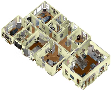
- Topographic surveys and 3D scanning
- Territory
- Anywhere in Quebec
Typical mandates
What we do for your projects
- Cadastral operations: dividing, merging or modifying lots.
- Subdivision plans for residential, commercial or industrial projects.
- Proposed site plans and site certificates for municipal requirements.
- Topographic site surveys by ground survey, 3D scanner or drone.
What you receive
A file ready for the municipality
Plans that meet bylaw requirements, to support your permit applications.
An accurate picture of the site
Boundaries, levels and existing infrastructure, the basis of your concept.
Documents delivered
- 01Subdivision plan and filing with the Quebec cadastre.
- 02Proposed site plan and site certificate.
- 03Topographic plan in DWG and point cloud when needed.
Before you hire us
Frequently asked questions
“We want to subdivide land for a residential project. Where do we start?”
With a cadastral operation. The land surveyor prepares the subdivision plan, checks compliance with municipal bylaws and files it with the Quebec cadastre.
“The municipality requires a proposed site plan. Can you prepare it?”
Yes. We position the proposed building on the lot, accounting for setbacks, servitudes and regulatory constraints, to support your permit application.
“Do you need a survey before the project is designed?”
Often, yes. A topographic survey of the site provides levels, existing infrastructure and boundaries: the basis of your development concept.
A development project? Let's talk
Describe the land and the intended project, and attach your sketches or preliminary plans.