%20--%3e%3cdefs%3e%3cstyle%3e%20.st0%20{%20fill:%20%23989aa5;%20}%20.st1%20{%20fill:%20%230051bb;%20}%20%3c/style%3e%3c/defs%3e%3cg%3e%3cpolygon%20class='st0'%20points='69.2602%2069.4737%20104.6531%2069.4737%20104.6531%2060.4924%2078.1083%2060.4924%2078.1083%2051.6441%20100.2289%2051.6441%20100.2289%2042.796%2078.1083%2042.796%2078.1083%2033.9477%20104.6531%2033.9477%20104.6531%2025.0574%2069.2602%2025.0574%2069.2602%2069.4737'/%3e%3cpolygon%20class='st0'%20points='160.1877%2054.5947%20138.0841%2025.1016%20129.219%2025.0574%20129.219%2069.3406%20138.0841%2069.3406%20138.0841%2039.8726%20160.1877%2069.3406%20169.0361%2069.3406%20169.0361%2025.0574%20160.1877%2025.0574%20160.1877%2054.5947'/%3e%3crect%20class='st0'%20x='193.602'%20y='25.0574'%20width='8.8483'%20height='44.2832'/%3e%3cpath%20class='st0'%20d='M24.8244,42.8324l-3.541,8.8483h15.2613c-1.8651,5.6716-7.2032,9.7815-13.491,9.7815-7.833,0-14.2056-6.3726-14.2056-14.2058s6.3726-14.2056,14.2056-14.2056c1.8661,0,3.6346.3885,5.2643,1.0519l3.3011-8.2495c-2.6485-1.0617-5.5372-1.6505-8.5654-1.6505C10.3215,24.2026,0,34.5241,0,47.2564s10.3215,23.0541,23.0537,23.0541,23.0541-10.3217,23.0541-23.0541c0-1.5142-.1558-2.9912-.4345-4.424h-20.849Z'/%3e%3cpath%20class='st0'%20d='M416.5159,25.0996l-19.9084-.0422v44.2834h8.8479v-13.2657l11.0605-.0068c8.5164,0,15.4841-6.968,15.4841-15.4845h0c0-8.5164-6.9676-15.4843-15.4841-15.4843ZM423.1841,40.5574c0,3.653-2.9888,6.6415-6.6417,6.6415h0l-11.0869.0186v-13.3017h11.0869c3.653,0,6.6417,2.9886,6.6417,6.6415h0Z'/%3e%3cpath%20class='st0'%20d='M372.0412,40.5838h0c0-8.5164-6.968-15.4843-15.4841-15.4843l-19.9084-.0422v44.2834h8.8479v-13.2657l11.0605-.0068c.2927,0,.5782-.028.8674-.0442l5.3337,13.3261h9.5257l-6.537-16.3462c3.8061-2.828,6.2942-7.3417,6.2942-12.4201ZM363.2253,40.5574c0,3.653-2.9892,6.6415-6.6417,6.6415l-11.0869.0186v-13.3017h11.0869c3.6526,0,6.6417,2.9886,6.6417,6.6415h0Z'/%3e%3cpath%20class='st0'%20d='M290.3093,3.7965l-4.4639,7.7364c9.8109,3.9189,17.6019,11.8447,21.342,21.7439h9.345c-3.9549-13.2573-13.6662-24.0553-26.2231-29.4803Z'/%3e%3c/g%3e%3cg%3e%3cpath%20class='st1'%20d='M253.0626,68.3533l10.0145-17.3576h-10.2284l-5.8264,10.0983c1.6066,2.7405,3.6519,5.1914,6.0403,7.2593Z'/%3e%3cpath%20class='st1'%20d='M318.2553,42.1363h-32.413l-13.9411-24.1626-13.941,24.1626h10.2282l3.7128-6.4351,18.8386,32.6521c2.3883-2.0679,4.4338-4.5188,6.0403-7.2595l-5.8262-10.0981h18.3924c-2.1998,18.7116-18.152,33.2769-37.445,33.2769-20.7916,0-37.7069-16.9149-37.7069-37.7066s16.9153-37.7066,37.7069-37.7066c1.7163,0,3.4054.1176,5.0615.3408l4.711-8.1652c-3.1525-.6759-6.4211-1.035-9.7724-1.035-25.6767,0-46.5664,20.8893-46.5664,46.566s20.8897,46.566,46.5664,46.566,46.566-20.8893,46.566-46.566c0-1.4941-.0736-2.9712-.212-4.4297Z'/%3e%3c/g%3e%3c/svg%3e)
Design on data you won't have to double-check
Your drawings are only as good as the initial survey. We document existing conditions in full and deliver files ready to open.
Reply within 24 business hours
- Delivery formats
- RCP/RCS, E57, LAS, DWG
- Compatibility
- Revit, Civil 3D, AutoCAD
- Sharing
- a collaborative project platform
- Signature
- Land surveyor, member of the Order
The missing detail that costs you an addendum
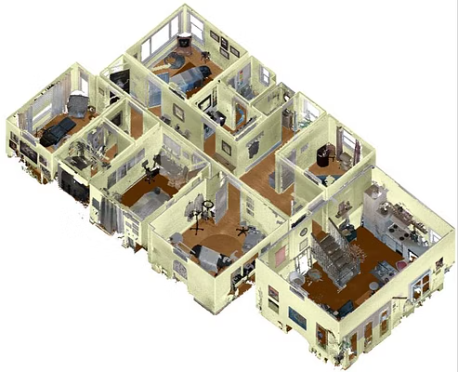
A conventional survey captures what seemed relevant that day. Scanning captures everything: the missing data is already in the point cloud.
- Existing-conditions survey before design: natural terrain, buildings, utilities and easements.
- Georeferenced point clouds, usable in section and elevation at any point in the project.
- Verification of design assumptions without redeploying a crew.
Typical deliverables
Survey plans and profiles
Point clouds and meshes
Files handed to your design team
- 01Georeferenced point cloud, raw and processed.
- 02Survey plans, profiles and sections following your templates.
- 03Shared access via a collaborative project platform for the whole design team.
A complete survey beats a second site visit
Send us the footprint and your schedule: we confirm the method, achievable accuracy and delivery date.
Request a quoteWhat designers want to know before hiring us
“Is your data compatible with our BIM environment?”
Yes. Point clouds are delivered in standard formats (RCP/RCS, E57, LAS), so they import directly into Revit, Civil 3D and AutoCAD. CAD plans follow your templates and layer conventions: tell us yours at the quote stage rather than after delivery.
“How much time between the mandate and the data?”
Field work for a standard existing-conditions survey takes one to two days. Processing and CAD production follow, depending on complexity. The delivery date is stated in the quote: we don't accept it if we can't meet it.
“What if we discover something missing during design?”
With a point cloud, the data is already there: we extract the missing section or elevation without returning to the site. That's exactly what prevents addenda and team call-backs.
“Who signs and seals the documents?”
Documents that require it are signed and sealed by a land surveyor who is a member of the Order. You'll have the name of your file's lead as soon as the quote is accepted.
A project in the works? Let's talk about the initial survey
Describe the mandate, attach your preliminary drawings and let us know when you need the data.