%20--%3e%3cdefs%3e%3cstyle%3e%20.st0%20{%20fill:%20%23989aa5;%20}%20.st1%20{%20fill:%20%230051bb;%20}%20%3c/style%3e%3c/defs%3e%3cg%3e%3cpolygon%20class='st0'%20points='69.2602%2069.4737%20104.6531%2069.4737%20104.6531%2060.4924%2078.1083%2060.4924%2078.1083%2051.6441%20100.2289%2051.6441%20100.2289%2042.796%2078.1083%2042.796%2078.1083%2033.9477%20104.6531%2033.9477%20104.6531%2025.0574%2069.2602%2025.0574%2069.2602%2069.4737'/%3e%3cpolygon%20class='st0'%20points='160.1877%2054.5947%20138.0841%2025.1016%20129.219%2025.0574%20129.219%2069.3406%20138.0841%2069.3406%20138.0841%2039.8726%20160.1877%2069.3406%20169.0361%2069.3406%20169.0361%2025.0574%20160.1877%2025.0574%20160.1877%2054.5947'/%3e%3crect%20class='st0'%20x='193.602'%20y='25.0574'%20width='8.8483'%20height='44.2832'/%3e%3cpath%20class='st0'%20d='M24.8244,42.8324l-3.541,8.8483h15.2613c-1.8651,5.6716-7.2032,9.7815-13.491,9.7815-7.833,0-14.2056-6.3726-14.2056-14.2058s6.3726-14.2056,14.2056-14.2056c1.8661,0,3.6346.3885,5.2643,1.0519l3.3011-8.2495c-2.6485-1.0617-5.5372-1.6505-8.5654-1.6505C10.3215,24.2026,0,34.5241,0,47.2564s10.3215,23.0541,23.0537,23.0541,23.0541-10.3217,23.0541-23.0541c0-1.5142-.1558-2.9912-.4345-4.424h-20.849Z'/%3e%3cpath%20class='st0'%20d='M416.5159,25.0996l-19.9084-.0422v44.2834h8.8479v-13.2657l11.0605-.0068c8.5164,0,15.4841-6.968,15.4841-15.4845h0c0-8.5164-6.9676-15.4843-15.4841-15.4843ZM423.1841,40.5574c0,3.653-2.9888,6.6415-6.6417,6.6415h0l-11.0869.0186v-13.3017h11.0869c3.653,0,6.6417,2.9886,6.6417,6.6415h0Z'/%3e%3cpath%20class='st0'%20d='M372.0412,40.5838h0c0-8.5164-6.968-15.4843-15.4841-15.4843l-19.9084-.0422v44.2834h8.8479v-13.2657l11.0605-.0068c.2927,0,.5782-.028.8674-.0442l5.3337,13.3261h9.5257l-6.537-16.3462c3.8061-2.828,6.2942-7.3417,6.2942-12.4201ZM363.2253,40.5574c0,3.653-2.9892,6.6415-6.6417,6.6415l-11.0869.0186v-13.3017h11.0869c3.6526,0,6.6417,2.9886,6.6417,6.6415h0Z'/%3e%3cpath%20class='st0'%20d='M290.3093,3.7965l-4.4639,7.7364c9.8109,3.9189,17.6019,11.8447,21.342,21.7439h9.345c-3.9549-13.2573-13.6662-24.0553-26.2231-29.4803Z'/%3e%3c/g%3e%3cg%3e%3cpath%20class='st1'%20d='M253.0626,68.3533l10.0145-17.3576h-10.2284l-5.8264,10.0983c1.6066,2.7405,3.6519,5.1914,6.0403,7.2593Z'/%3e%3cpath%20class='st1'%20d='M318.2553,42.1363h-32.413l-13.9411-24.1626-13.941,24.1626h10.2282l3.7128-6.4351,18.8386,32.6521c2.3883-2.0679,4.4338-4.5188,6.0403-7.2595l-5.8262-10.0981h18.3924c-2.1998,18.7116-18.152,33.2769-37.445,33.2769-20.7916,0-37.7069-16.9149-37.7069-37.7066s16.9153-37.7066,37.7069-37.7066c1.7163,0,3.4054.1176,5.0615.3408l4.711-8.1652c-3.1525-.6759-6.4211-1.035-9.7724-1.035-25.6767,0-46.5664,20.8893-46.5664,46.566s20.8897,46.566,46.5664,46.566,46.566-20.8893,46.566-46.566c0-1.4941-.0736-2.9712-.212-4.4297Z'/%3e%3c/g%3e%3c/svg%3e)
High-precision ground, hydrographic and LiDAR surveys
The accurate data your designers need, delivered in the format you choose.
DWG, LandXML and E57 point cloud, ready to open
- Scope
- Land, building, confined space and water bottom in one survey
- Formats
- DWG, LandXML, E57 point cloud, BIM-compatible
- Technologies
- Total station, RTK GPS, drone LiDAR, SLAM mobile scanning
Field data ready to use immediately
Ground surveys and LiDAR combined: point clouds, plans and models suited to your deliverables.
- Conventional ground surveys with total station and RTK GPS.
- Drone LiDAR acquisition to cover large areas quickly.
- For very large areas, airborne LiDAR is delivered through a partnership with specialized firms, coordinated by Géniarp.
- Drone surveys for extensive, hard-to-access or hazardous sites.
- Shoulder-mounted mobile scanner: continuous 360° capture, nothing missed along the technician's path.
- Deliverables tailored to your design platforms.
What you receive
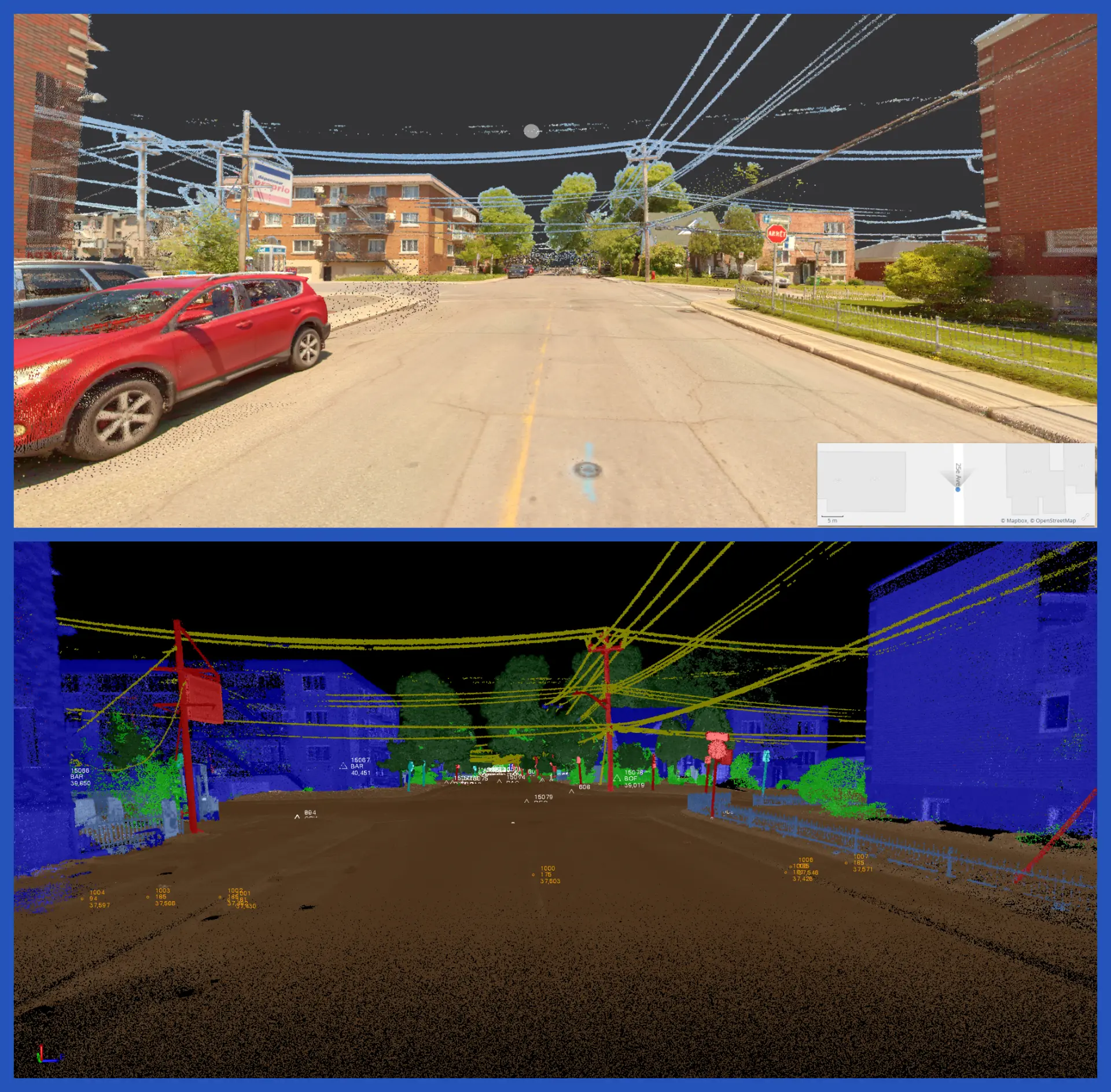
- 01Georeferenced point cloud (E57 or RCP format).
- 02CAD topographic plan in DWG and LandXML formats.
- 033D model compatible with your BIM/Revit workflows.
- 04Signed and sealed survey report when required.
The point cloud builds in front of you
During the survey, data appears in real time: coverage is validated before we leave the site, never after.
SLAM mobile scanning: NavVis VLX3
Capture by walking the site: your operations continue while we survey.
Capture while walking
Zero blind spots
Zero interruption
Where our surveys are used
- Preconstruction studies and feasibility validation.
- Base plans for engineering and architecture firms.
- Municipal surveys of infrastructure and rights-of-way.
Specialized capabilities
- Industrial surveys with BIM-compatible modelling.
- Confined-space work by staff trained to CNESST requirements: winch, harness, gas detector, ventilator, mobile unit.
- Precision scanning of valve chambers and underground infrastructure.
- Complete management of info-excavation requests, from application to survey.
- Installation of permanent geodetic reference points.
Built for design teams and asset managers
- Civil engineering and environmental firms.
- Architects and landscape architects.
- Municipalities and institutional projects.
- Ministries, including the Ministère des Transports (MTQ).
- Hydro-Québec and network operators.
- Port authorities and marine infrastructure.
How a survey unfolds
The same path on every mandate, from scoping to file delivery.
Scoping the need
Extent, required accuracy and end use of the data determine the method: total station, GNSS, SLAM or LiDAR.
Capture on site
An assigned crew surveys the site and validates coverage on the spot, before leaving.
Processing and drafting
Our calculators and drafters register the point cloud, georeference it and produce the CAD plan.
Delivery and follow-up
Files are delivered in your software formats, with one contact available for adjustments.
Topographic surveys: straight answers
What formats do we receive the data in?
Whatever suits your software: DWG and LandXML for your design platforms, E57 or RCP point clouds for Recap/Revit, and a signed and sealed PDF report when the mandate requires it.
How long does a topographic survey take?
Field capture generally takes one to a few days depending on area. Processing, computation and drafting follow in the office: the delivery date is confirmed in writing in your quote, depending on complexity and requested deliverables.
Does 3D scanning replace a conventional survey?
No, the two complement each other. SLAM scanning or LiDAR quickly capture large volumes of data; the total station and RTK GPS confirm geodetic accuracy at critical points. We combine both depending on the accuracy required.
Can you work on an operating site?
Yes. Mobile scanning captures while walking, with no production stoppage. For confined spaces or higher-risk areas, our staff are trained to CNESST requirements (winch, harness, gas detector, ventilation).
Do you handle info-excavation requests?
Yes, we manage the info-excavation request from start to finish when the mandate includes a survey of underground infrastructure.
What our clients say
“At GHD, we have worked with GéniArp for many years on a wide range of infrastructure and development projects. Their team stands out for its professionalism, rigour and responsiveness. Surveys and deliverables are always of high quality, schedules are met and communication is effective throughout the mandates.”
“We have been working with Geniarp for years. Professional and fast service for our topographic surveys for various civil engineering and water treatment projects.”
Schedule your topographic survey
Send us the area to cover and the expected format (DWG, IFC, point cloud) and you get a firm schedule.